USGS.10.02 Missouri Headwaters

The USGS Missouri River Headwaters is located in Southwest Montana and flows into the Upper Missouri. at the confluence of the Jefferson River (10020005), Madison River (10020007), and the Gallatin River (10020008) to form the Missouri River near Three Forks, Montana.
Detail Watershed Regions show on the right in the Level 3 Map.
PD4 Adaptation of USGS Mapping
The USGS System Decomposition for the US is typical of Large Scale Systems Integration as found in Automotive, Aerospace, Shipbuilding, and Telecommunications. The USGS provides a good sample of using a "Visual Index" or "Structural Schematic" to easily organize and access information. The USGS System also provides a good example of the connective structure or topology of the "River System"...and the connectivity of its "Installation Zones."
PD4 adapts the USGS structure for enhancement to:
- Enhance visibility of mainstream flow of a River System into, out of, and through a Zone.
- Provide links to additional information on Streams and
associated Regions including:
- Online 2D and 3D Maps
- Wikipedia descriptions of Streams, Continental Divide, and cities
- The original USGS "Science in Your Watershed" Visual Index
- The EPA Watershed information which uses the same Watershed ID's
- PD4 Vertical Decomposition
- PD4 Horizontal Traversal through the flow paths...e.g. click from Missouri Headwaters to New Orleans
- Demonstration of Systems Engineering Logical Mapping usging UGS Teamcenter Systems Engineering
- Microsoft Visio both with and without Teamcenter Engineering
PD4 Adaptation of USGS
The PD4 Adaptation of the USGS for 100200 above is shown below with enhanced flow information including Logical Left and Real Right enhanced flow paths or inputs.
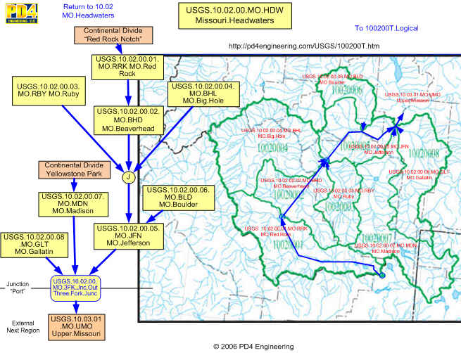
For clarity PD4 separates the 4 Levels with periods.
USGS.10.02.00 Overview Table of Contents
The following links to watershed flow description in terms of Watershed Systems/Zones.:
- USGS.10.02.00.01 Red Rock...flows from Red Rock "Notch" in SE corner to Clark Canyon Reservoir in Central NW
- USGS.10.02.00.02 Beaverhead...flows from Clark Canyon Dam to Junction with Big Hole near Twin Bridges, MT
- USGS.10.02.00.03 Ruby...flows from headwaters on the South to Northwest Junction with Beaverhead
- USGS.10.02.00.04 Big Hole...flow in a "C" from North of Red Rock Zone to Junction with Beaverhead to form Jefferson River
- USGS.10.02.00.05 Jefferson...flows from headwaters in SW corner to NW corner
- USGS.10.02.00.06 Boulder ...flows into the Jefferson above the Three Forks, MT Junction
- USGS.10.02.00.07 Madison...flows from its headwaters in Central Yellowstone Park
- USGS.10.02.00.08 Gallatin...flows from its headwaters in the Northwest corner of Yellowstone Park
USGS.10.02.00.01 Red Rock Overview
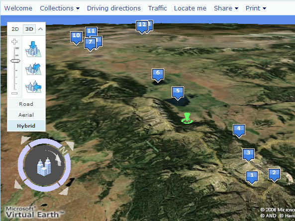
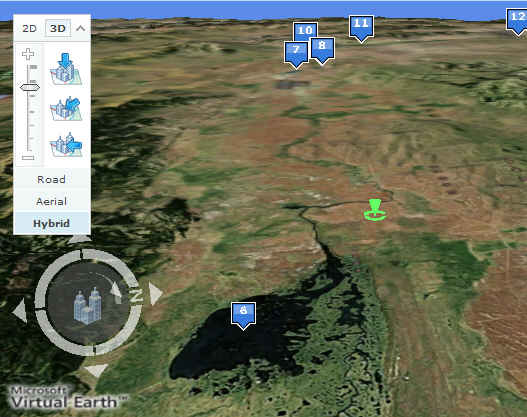
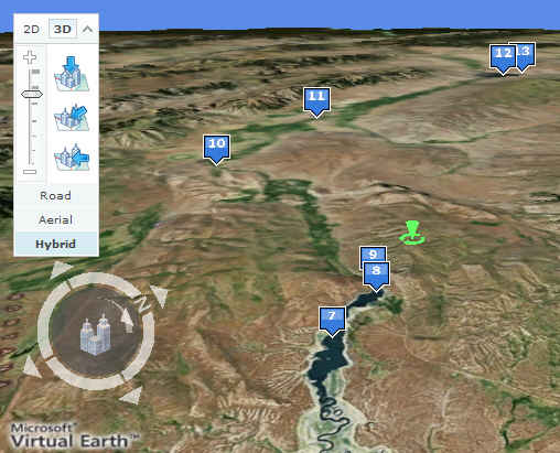
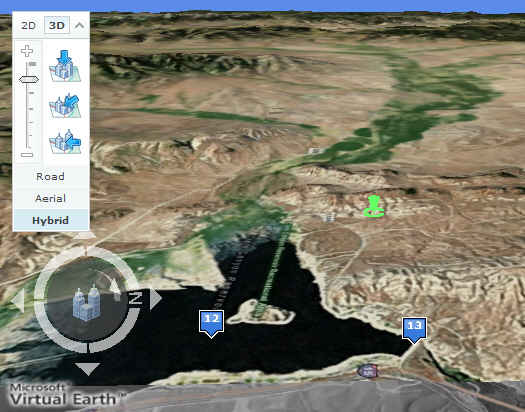
The 3D Overview of the Red Rock Watershed is the longest length source of the Missouri River. The Red Rock starts in a Canyon at the Continental Divide (1) with longest length (2). Mount Jefferson (3) is a key feature. The Red Rock exits the Canyon (4) and turns left toward Upper Red Rock Lake (5) and Lower Red Rock Lake (6) where the stream becomes Red Rock River. The River flows onto Lima Reservoir (7) and Dam (8) with a USGS Measurement Station 9. The Red Rock flows past (10) then a junction with Big Sheep Creek Watershed which drains the hills to the West on the Left Bank. The Red Rock flows to the Clark Canyon Rerservoir (12) and Dam (13). The stream becomes the Beaverhead River as it exits the Dam.
MS Virtual Earth...2D and 3D Viewing with Windows Live Local plus 3D Virtual Earth download.
Red Rock...Devils Gulch Canyon Source
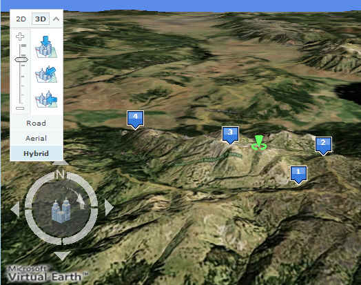
With a view to the North, The Red Rock Creek Source (1) is identified as the junction of rivulets flowing down from the Continental Divide. The Longest Length (2) is on the Continental Divide between Idaho on the North and Montana on the South. Note that this is counterintuitive to normal thinking of Montana being North of Idaho, but this is a "hook" feature in the Continental Divide Boundary between the two states. This is similar to having to drive South to Canada out of Detroit. Mount Jefferson is a Key Terrain Feature on the North of Zone, which helps locate the Source Zone. Red Rock Creek exits at the bottom of the Canyon and turns left toward the Red Rock Lakes (5 and 6 below).
Red Rock...Upper and Lower Red Rock Lakes
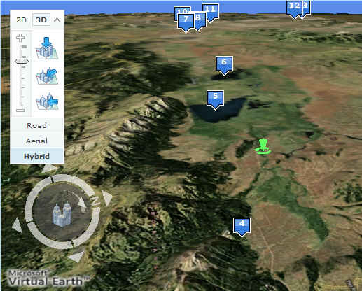
Turning left on exiting Devil's Gulch, Red Rock Creek flows to Upper Red Rock Lake (5), and then onto Lower Red Rock Lake. These both reside in the Red Rock Lakes Wilderness.
Red Rock...Upper Watershed 2D Logical Schematic on USGS Map
The 2D Upper Red Rock Subwatershed Map shows the upper and Red Rock Lakes creek watershed into Red Rock Creek.
This adapts Visio as a structural schematic supersimposed on the USGS Map. Detailed Streams are derived from the tooltips information on the USGS 10020001 Map. These have additional links to detail stream end locations and Google Map links from Lat-Long.com.
Red Rock...Lower Red Rock Lake to Lima Reservoir
Exiting Red Rock Lakes, the designation for the Red Rock stream changes to Red Rock River as it flows West to Lima Reservoir (7).
Lima Reservoir to Clark Canyon Reservoir.
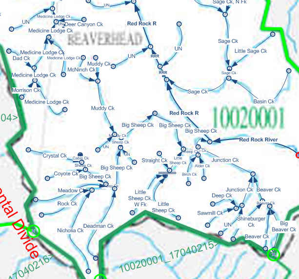
The Lima Reservoir (7) and Dam (8) is a man-made Reservoir for river flow control. The first USGS Streamflow Measurement Station (9) is located immediately downstream from the Lima Dam. The Red Rock River flows through the town of Lima, MT (10) where it takes a turn toward the Clark Canyon Reservoir (12). The Big Sheep Creek (11) joins the Red Rock River, draining the major hilly canyon terrain on the Left Bank, West of Red Rock as the Junction Creek Watershed drains the South, and joining the Big Beaver Creek as it flows through a canyon in the hills to join the Red Rock.
Red Rock...Middle Watershed 2D Schematic
The Clark Canyon Reservoir (12) and Dam (13) has flow input from the Red Rock and the
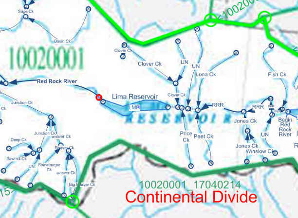
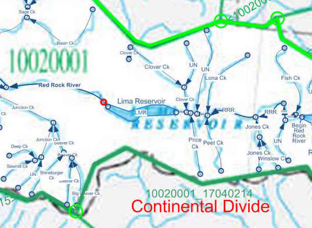
The Middle Red Rock Subwatershed map shows the drainage flowing into the Red Rock River from the exit from Lower Red Rock Lake, through the Lima Reservoir (7), to the Big Sheep Creek downstream from the town of Lima. The red circle is a PD4 convention identifying USGS Stations. The first is immediately below the Lima Dam. The Schematic provides links to Real Time Measurements for Height and Flow Volume.
Red Rock...Big Sheep Creek Subwatershed
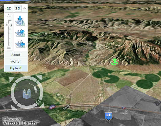
A view West from the Junction of the Big Sheep Creek shows the Foothill complex with Junction Creek flowing from the South joining the Big Sheep Creek flowing from the North...and then flowing through foothill pass as the Big Sheep Creek to Junction with the Red Rock River. (11).
Red Rock...Big Sheep Creek...2D Schematic
The Big Sheep Creek Subwatershed is shown in 2D Flow Schematic of the 3D shown above. This shows the complexity of this watershed as it collects water runoff from foothills in the North and the South.
Red Rock...Lower Watershed and Clark Canyon Reservoir
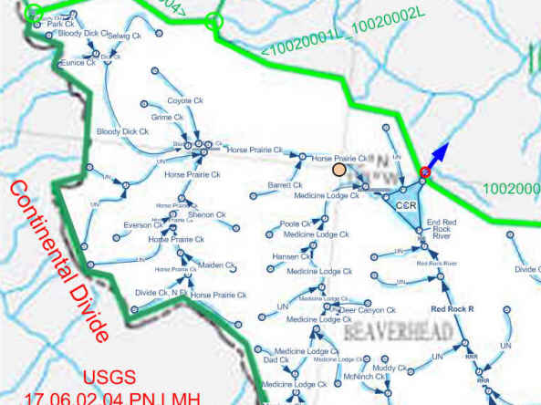
Clark Canyon Reservoir (12) is shown with Clark Canyon Dam (13) operating as the Interface Criteria Definition for the Beaverhead River USGS.10020002. in this view, Red Rock River flows into the Reservoir from the South on the right below. This view also shows Horse Prairie Creek flowing from the Northwest, joining Medicine Lodge Creek flowing from the South. Medicine Lodge Creek the flows into Clark Canyon Reservoir.
Red Rock...Lower Red Rock 2D Schematic
The 2D Flow Diagram details the flow of the Red Rock River ,and the Horse Prairie and Medicine Lodge Creeks shown in 3D above.
USGS.10.02.00.02 Beaverhead
USGS.10.02.00.03 Ruby
USGS.10.02.00.04 Big Hole
USGS.10.02.00.05 Jefferson
USGS.10.02.00.06 Boulder
USGS.10.02.00.07 Madison
USGS.10.02.00.08 Gallatin
